Distributor Rutronik has added three surface-mount RTK-enhanced GNSS modules from Unicore to its portfolio. RTK – ‘real time kinematics’ – is a service that increases the accuracy of satellite navigation systems. UM982 GPS L1/L2/L5 BDS B1I/B2I/B3I GLONASS G1/G2 Galileo E1/E5a/E5b QZSS L1/L2/L5 SBAS 16 x 21 x 2.6mm UM980 BDS B1I/B2I/B3I/B1C/B2a/B2b GPS L1/L2/L5 GLONASS L1/L2 Galileo E1/E5a/E5b QZSS L1/L2/L5 SBAS ...
Tag Archives: navigation
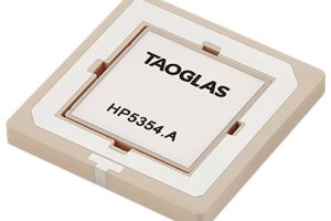
Dual-band patch-in-patch GNSS antenna is 4mm thick
Taoglas has inset one antenna inside another to cover GNSS L1 and L5 with a 35 x 35 x 4mm surface-mount device – which is optimised for use on a 70 x 70mm ground plane. Designed using a custom electro-ceramics formula, HP5354.A offers “stacked patch L1-L5 performance” within a single patch-in-a-patch solution, according to the company. It “has a passive ...
Quantum navigation components demonstrated in flight
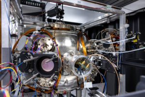
A consortium has demonstrated quantum-based inertial navigation in an aircraft, the first such demonstration to be made public, according to the UK Government’s Department for Science, Innovation and Technology (DSIT). By using quantum-based references in the accelerometers and gyros at the heart of an intertial measurement unit (IMU), it is theoretically possible to maintain absolute accuracy over time as an ...
Royal Navy tests quantum navigation sensor from Imperial College
An Imperial College prototype quantum accelerometer has been tested on a Royal Navy ship. The accelerometer uses ultra-cold atoms, whose wave-like properties allow them to be measured accurately by lasers as they move under acceleration. Quantum accelerometers and gyros are of enormous interest for inertial navigation systems as the quantum nature of the parameters measured have the potential to offer ...
BAE Systems wins contract for E-2D Advanced Hawkeye’s IFF capabilities
BAE Systems has won a $26 million contract to support Identification Friend-or-Foe (IFF) capabilities for the U.S. Navy’s E-2D Advanced Hawkeye aircraft it has announced. Under the terms of the contract, the company will provide Beamforming Networks (BFNs) – an integral part of antenna control for the AN/APX-122A IFF Interrogator system – onboard the carrier-capable tactical aircraft. The goal of ...
AI helps robots and drones navigate with phone-grade cameras and inertial sensors
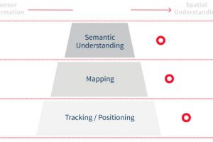
Imperial College spin-out Slamcore is developing artificial intelligence based tools to help robots both map their environment and navigate through it – ‘slam’ in the name comes from ‘simultaneous localisation and mapping’. “We are experts in the probabilistic fusion of multiple types of sensor,” Slamcore CEO Owen Nicholson told Electronics Weekly. “Our AI algorithms have been designed to take the ...
Sat nav module adds inertial navigation for self-driving cars
U-blox is adding inertial dead-reckoning to satellite-based signals to improve navigation in locations with poor reception – like challenging urban environments. To be implemented in ZED-F9K – samples planned from July – will have a multi-band GNSS (global navigation satellite system) receiver, inertial sensors (3d accelerometer, 3d gyroscope), signal processing algorithms and correction services “to deliver down to decimeter-level accuracy ...
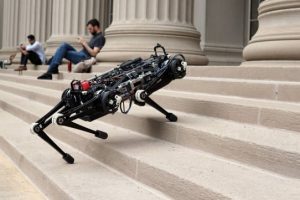
MIT removes the need for vision in stair-climbing robot
The MIT Cheetah 3 robot canrun across rough terrain and climb staircases by touch alone.
Shoe sensor adds dead-reckoning to GPS
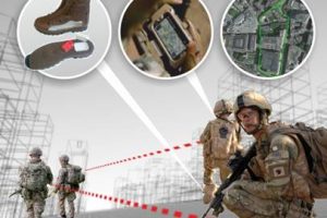
Raytheon UK has developed a positioning and navigation system that adds 3D dead-reckoning to global navigation satellite systems (GNSSs, GPS for example), allowing navigation inside buildings. Called ‘Strider’, it comes in two parts – a ‘boot-mounted unit’ (BMU) and a phone app. Inside the BMU are MEMS accelerometers, gyros and a pressure sensor (height). This communicates with the ‘Strider Location ...
Pressure sensor tells you which floor
Altitude-based floor level tracking is possible using barometric pressure sensors, claims sensor-maker Bosch, which is suggesting them for asset tracking, personnel tracking, shopping mall guidance and emergency applications such as E911 and Blue force. Californian service-provider NextNav is using them as part of a positioning system that allows phones to determine their location in indoor and urban environments where GPS signals ...
 Electronics Weekly Electronics Design & Components Tech News

